There’s a moment that happens on many renovation and retrofit projects where the team realizes something uncomfortable.
The drawings don’t fully match the building anymore.
A duct sits lower than expected. Structural framing appears slightly different from archived plans. Equipment layouts have changed over the years, but the documentation never really caught up.
And suddenly, before any BIM coordination can even begin, the project faces a more basic problem:
“What exactly are we working with?”
That question is becoming increasingly common across the AEC industry—especially in renovation, industrial, infrastructure, and adaptive reuse projects. Because despite how advanced digital construction workflows have become, many existing buildings still rely on outdated CAD files, old PDFs, incomplete as-built drawings, or fragmented documentation gathered over decades.
This is exactly where the Point Cloud to 3D Model Process becomes important.
Not as a flashy technology trend. Not even primarily as a modeling service.
But as a way to establish something construction projects desperately need before coordination begins: reliable existing conditions.
Existing Buildings Are Rarely as Predictable as Their Drawings
New construction begins with design intent. Existing buildings come with history.
And history tends to leave behind inconsistencies.
Over time, buildings evolve. Production lines shift. Mechanical systems get upgraded. Renovations happen in phases. Contractors make field adjustments during construction. Temporary fixes quietly become permanent solutions.
But documentation? That doesn’t always evolve at the same pace.
This becomes especially noticeable in older facilities across cities like New York, Chicago, or industrial retrofit projects throughout Texas, where facilities have often undergone multiple upgrades over several decades.
By the time new work begins, teams are rarely dealing with one perfectly coordinated set of drawings. More often, they’re piecing together fragments of information from different timelines.
Why Manual Site Measurement Isn’t Always Enough
For years, site verification relied heavily on manual measurements and conventional drafting workflows. Teams would visit the site, capture dimensions selectively, and recreate drawings based on those observations.
The approach still works in some situations. But as projects become more complex, its limitations become harder to ignore.
Manual surveys typically:
- Capture selected dimensions rather than complete spatial context
- Depend heavily on field interpretation
- Leave room for missed deviations and undocumented changes
- Become increasingly difficult in congested industrial environments
And in highly coordinated projects, even small inaccuracies can create larger downstream issues. A few inches of deviation may affect:
- MEP coordination
- Fabrication clearances
- Equipment installation
- Structural framing interfaces
- Prefabricated assembly alignment
What Actually Happens During the Point Cloud to 3D Model Process?
This part often sounds more complicated than it really is.
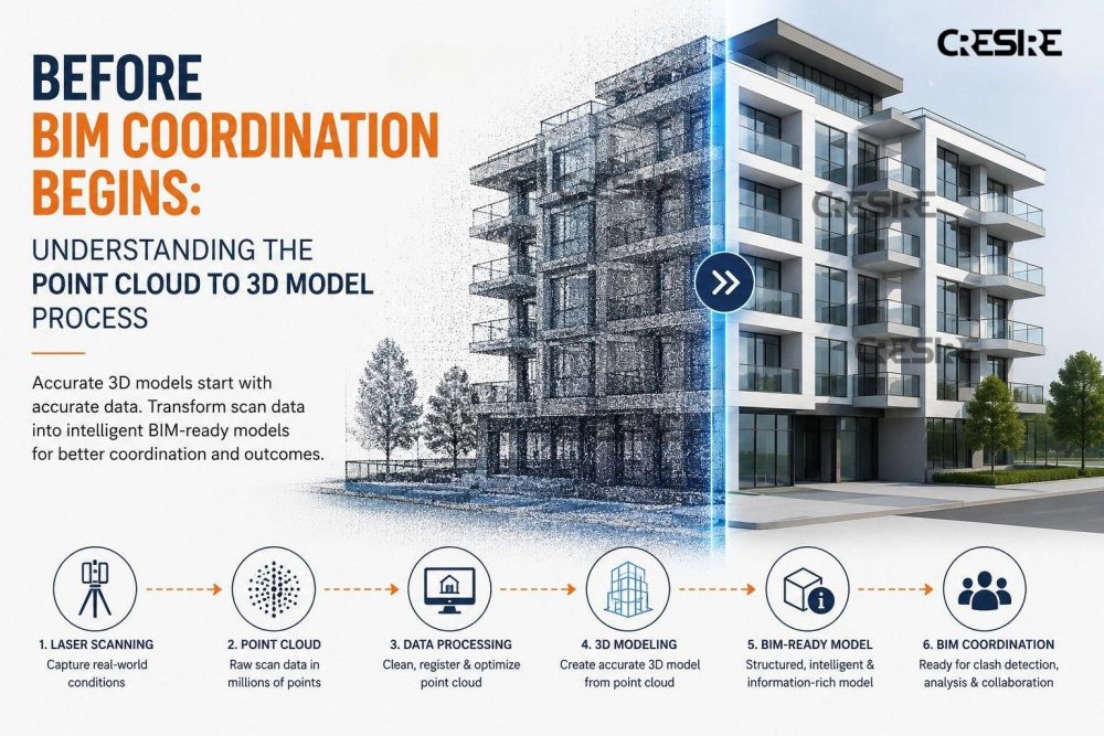
At its core, the Point Cloud to 3D Model Process is about converting real-world conditions into usable digital information.
The process usually begins with laser scanning.
Using high-precision scanners, technicians capture millions of spatial data points across the building or facility. These data points form what’s called a point cloud—essentially a highly detailed digital representation of the existing environment.
And this is where things get interesting.
The point cloud doesn’t just capture dimensions. It captures relationships:
- Structural geometry
- Equipment positioning
- Floor elevations
- Ceiling congestion
- Pipe routing
- Spatial clearances
In many ways, it captures the building as it actually exists—not simply how it was originally designed.
From Point Cloud Data to CAD and BIM Models
Raw point cloud data by itself isn’t enough for project coordination.
It’s detailed, yes. But also dense, complex, and not immediately usable for design workflows.
That’s where modeling begins.
Depending on project requirements, teams may develop:
- 2D CAD drawings through scan to CAD workflows
- Coordinated BIM models through point cloud to BIM workflows
- Hybrid documentation environments combining CAD and BIM data
This stage often includes:
- Geometry interpretation
- Structural modeling
- MEP system reconstruction
- Architectural drafting
- Layer organization and model coordination
And importantly, the quality of this stage matters just as much as the scan itself.
Because a point cloud only provides raw spatial information. The real value emerges when experienced teams translate that information into coordinated digital models that architects, engineers, contractors, and fabrication teams can actually work with.
Why Scan to CAD Still Matters in Modern BIM Workflows
Interestingly, even in highly BIM-driven projects, scan to CAD workflows remain incredibly relevant.
Not every project immediately requires a full BIM model. In many renovation and retrofit projects, teams first need:
- Accurate floor plans
- Updated reflected ceiling plans
- Equipment layouts
- Structural drafting
- Existing-condition documentation
This is where laser scan to CAD workflows often become the first step before BIM development begins.
Many fabrication teams, consultants, facility managers, and contractors continue relying on CAD-based deliverables for portions of project coordination and documentation.
The Real Goal of Point Cloud to BIM is Reducing Uncertainty
This is probably the most misunderstood part of the conversation.
People often assume the goal of the Point Cloud to BIM workflow is simply to create accurate models.
But accuracy alone isn’t really the end objective.
The real goal is reducing uncertainty before construction begins.
Because uncertainty creates:
- Coordination conflicts
- Site revisions
- Fabrication issues
- Construction delays
- Rework costs
And these problems become far more expensive once physical work starts on site.
That’s why the value of scan to BIM isn’t just technical—it’s operational.
Reliable existing-condition data allows teams to make better decisions earlier:
- Can new systems actually fit within available space?
- Will prefabricated assemblies align correctly?
- Are maintenance clearances achievable?
- Will new structural modifications interfere with existing services?
Why the Point Cloud to BIM Workflow Is Becoming More Important
Across the AEC industry, projects are becoming:
- More renovation-driven
- More prefabrication-focused
- More dependent on multidisciplinary coordination
- Less tolerant of field uncertainty
That shift naturally increases the importance of reality capture workflows.
And as BIM coordination becomes more connected to fabrication, scheduling, and facility operations, the accuracy of existing-condition modeling becomes even more critical.
Because at some point, the project stops being about drawings altogether.
It becomes about whether the digital environment truly reflects the physical one.
Final Thought
Before BIM coordination begins, something more fundamental has to happen first. Teams need confidence that the information they’re building around is accurate.
That’s really what the Point Cloud to 3D Model Process provides.
Not just scans. Not just CAD files. Not just BIM models. But a dependable understanding of existing conditions before major design, coordination, and construction decisions begin.
And in an industry where small inaccuracies can quietly grow into major project issues, that clarity often matters far more than people initially expect.